Students will research and present findings on a minimum of two case studies and applications. One of these must come from the list provided, one can be of your choice.
Details on format and presentation will be provided at a later date.
History of Commercial Logging in BC
Tropical Rainforests
Guidelines for defining Forest Resources
Sustainable Forests: the Swedish Model
Sustainable Forests: Canada
Regional Aquatics Monitoring Program (RAMP)
Watersheds
Aral Sea Disaster
Cement: Cox Station Quarry Blast
The Power of Place: Geography for the 21st century Case Studies
Landslides
Karst Landscapes
Streams
Medicine Hat
River Pollution
Stream Restoration
Tuesday, May 5, 2015
Sunday, April 26, 2015
Shaping Processes TERM 2
The atmosphere of the earth is divided into several layers. The layer closest to earth, the troposphere, is the layer where weather plays an important role in shaping the landscape through processes of gradation and deposition. Weathering loosens rock materials, and different weathering agents, running water, ice, wind, ocean waves, create unique erosional and depositional landforms.
This unit on geomorphology examines these processes and evaluates them with respect to how humans have been able to adapt or modify the landscapes resulting from these processes.
This unit on geomorphology examines these processes and evaluates them with respect to how humans have been able to adapt or modify the landscapes resulting from these processes.
Shaping Processes
Weathering Agents: Running
Water, Ice, Wind, Oceans
Gradational Landforms
Depositional Landforms
Atmosphere, Weather and
Climate
Soil, Vegetation, and
Biomes
Mapping
Geocontext Profiler
Slope-gradient
Visualizing topography
Essential Reading: Weathering Group
Weathering
Weathering Flash Animation
Weathering
Essential Reading: Streams and Flooding Group
Weathering Diagrams and other geologic processes
Weathering Mechanical
Weathering Climate
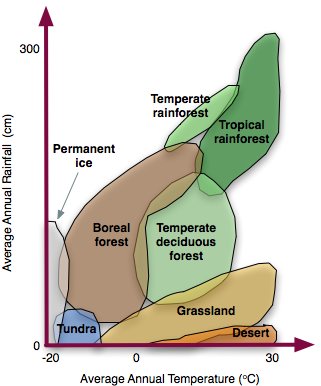
Biomes
Weathering & Sedimentary Rocks
Weathering Handout
Weathering Worksheet
Weathering Matching
Weathering Handout for students
Watersheds as Drainage Systems Required)
Flooding (Required)
Flood Forecasting
Flood Modelling
Virtual River
International Rivers
A river's journey from source to mouth
The River Severn from Source to Mouth
Dam Effects and Why we remove dams
China's Mega Dam Project Youtube
Teton Dam Disaster
Kame and Esker Formation
Glaciers and glacial landforms Group
Glacial Landforms PPT
Glacial Meltwater Landforms
Coasts and changing sea levels Group
Coastal Erosion and Deposition
Term 2 Schedule
Atmosphere Annenberg Video (Watch in class: Overview)a
Prehistoric atmosphere (Read different sections and prepare a graphic display for presentation)a
Atmospheric Circulation (Classwork: Overview and homework notes: Make sure you know this!)a
I.T.C.Z. Animation a
Climate of Tropical Regions
Atmospheric Circulation (Review)
Layers of the Atmosphere (Do this Assignment)
Atmosphere and Surface Energy Balance (Presentation in class and Classwork)a
Atmosphere Project (Individual or Group Assignment)a
Atmospheric Motion; (Background Reading)
Seasons Animation; (Sun-Earth Relations: In Class Demonstration)a
Planetary Circulation Patterns (Optional)
Solar Radiation & Seasons ( Optional Individual Lab)
Clouds
Clouds Presentation in Class (Presentation in class and discussion)
Air Pressure and Wind (Assignment) a
Land and Sea Breeze Animation a
Atmospheric Moisture (Optional Background Reading)
Atmospheric Moisture and Humidity Handout (Assignment)
Water Vapor Capacity of Air Handout (Assignment)
Atmospheric Stability Exercise (Handout)
Weather Systems (Optional Background Reading)
Atmospheric Interaction (Optional Background Reading)
El Nino (Current Events Reading)
El Nino Animation
Solar Energy (Solar Energy Application: Reading)
Climates (Optional Background Reading)
CO2 in a Year (Class demonstration and discussion)
Stable/ unstable air (Class demonstration)a
Stability PPTa
Weather Maps Practice and Help with your weather map activities
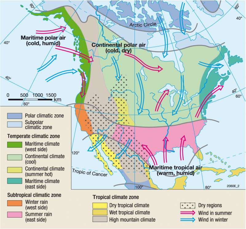
Climate Controls
North America Airmasses
North America Climate
Climate and Agriculture
Climate and cropping systems
Kashmir Case Study
Mediterranean Climates
Snowball Earth
Evolution of a Hurricane
Hurricane Katrina: Damage
Ice Core Records (Class discussion)
Tropical Meterology
Bohren: Clouds (Required Reading) a
Videos
Why do Clouds Stay Up?
Thunderstorms Affect Air Pollution
Ice Core Samples
High and Low Pressure a
Fair skies and dark skies
Understanding Synoptic Charts
Atmospheric Circulation and Question Sheeta
Jetstreams a
Atmosphere and Solar Windsa
Ocean Currents
Climate Animations
Koeppen Climate Classification
Snowball Earth
Virtual Skies NASA
Isotherm Contour Drawing Exercise online
Isobar Drawing Exercise online
Jet Stream and Jet Stream Animation a
Jet Streams
Rising air animation
Water Vapor Calculator
Orographic Lift and Orographic Lift animation
Weather Animations
MeteoEarth
Predict the weather
Canada Weather Analysis Charts
PPT (Class Demonstrations of key ideas)
1. Air Pollutants
2. Air Pollutants
3. Mass, Weight, Density, Pressure
4. Rising and Sinking Air
5. Surface Weather Maps
6. Upper Level Charts
7. Surface Weather Maps
8. Surface Weather Maps Analysis
9. Energy, Energy Transport
10. Temperature, Conduction, Convection, Latent Heat
Soils
Mapping
Geocontext Profiler
Slope-gradient
Visualizing topography
Essential Reading: Weathering Group
Weathering
Weathering Flash Animation
Weathering
Essential Reading: Streams and Flooding Group
Weathering Diagrams and other geologic processes
Weathering Mechanical
Weathering Climate
Biomes
Weathering & Sedimentary Rocks
Weathering Handout
Weathering Worksheet
Weathering Matching
Weathering Handout for students
Watersheds as Drainage Systems Required)
Flooding (Required)
Flood Forecasting
Flood Modelling
Virtual River
International Rivers
A river's journey from source to mouth
The River Severn from Source to Mouth
Dam Effects and Why we remove dams
China's Mega Dam Project Youtube
Teton Dam Disaster
- Stream Processes
- Fluvial Processes
- Streams
- Stream Lab
- Entrenched Meanders
- Chasing Rivers, Part I, Colorado River
- Chasing Rivers, Part II, The Ganges
- Causes of Flooding
- Flood Plains
- Arid Regions
Kame and Esker Formation
Glaciers and glacial landforms Group
Glacial Landforms PPT
Glacial Meltwater Landforms
- Glacier Lab
- Glacier Works and this
- Glaciers and erosion
- Glacier Simulation
- Glacier Modelling
- Glaciers Norway
- History of Ice Ages
- Ice Ages
- Gulf Stream and the next ice age
- Glaciation Lower Mainland
- Really Cool Alpine Glaciation Website
- Lake Agassiz
- Glacier Glossary
Coasts and changing sea levels Group
Coastal Erosion and Deposition
Term 2 Schedule
Atmosphere Annenberg Video (Watch in class: Overview)a
Prehistoric atmosphere (Read different sections and prepare a graphic display for presentation)a
Atmospheric Circulation (Classwork: Overview and homework notes: Make sure you know this!)a
I.T.C.Z. Animation a
Climate of Tropical Regions
Atmospheric Circulation (Review)
Layers of the Atmosphere (Do this Assignment)
Atmosphere and Surface Energy Balance (Presentation in class and Classwork)a
Atmosphere Project (Individual or Group Assignment)a
Atmospheric Motion; (Background Reading)
Seasons Animation; (Sun-Earth Relations: In Class Demonstration)a
Planetary Circulation Patterns (Optional)
Solar Radiation & Seasons ( Optional Individual Lab)
Clouds
Clouds Presentation in Class (Presentation in class and discussion)
Air Pressure and Wind (Assignment) a
Land and Sea Breeze Animation a
Atmospheric Moisture (Optional Background Reading)
Atmospheric Moisture and Humidity Handout (Assignment)
Water Vapor Capacity of Air Handout (Assignment)
Atmospheric Stability Exercise (Handout)
Weather Systems (Optional Background Reading)
Atmospheric Interaction (Optional Background Reading)
El Nino (Current Events Reading)
El Nino Animation
Solar Energy (Solar Energy Application: Reading)
Climates (Optional Background Reading)
CO2 in a Year (Class demonstration and discussion)
Stable/ unstable air (Class demonstration)a
Stability PPTa
Weather Maps Practice and Help with your weather map activities
Climate Controls
North America Airmasses
North America Climate
Climate and Agriculture
Climate and cropping systems
Kashmir Case Study
Mediterranean Climates
Snowball Earth
Evolution of a Hurricane
Hurricane Katrina: Damage
Ice Core Records (Class discussion)
Tropical Meterology
Bohren: Clouds (Required Reading) a
Videos
Why do Clouds Stay Up?
Thunderstorms Affect Air Pollution
Ice Core Samples
High and Low Pressure a
Fair skies and dark skies
Understanding Synoptic Charts
Atmospheric Circulation and Question Sheeta
Jetstreams a
Atmosphere and Solar Windsa
Ocean Currents
Climate Animations
Koeppen Climate Classification
Snowball Earth
Virtual Skies NASA
Isotherm Contour Drawing Exercise online
Isobar Drawing Exercise online
Jet Stream and Jet Stream Animation a
Jet Streams
Rising air animation
Water Vapor Calculator
Orographic Lift and Orographic Lift animation
Weather Animations
MeteoEarth
Predict the weather
Canada Weather Analysis Charts
PPT (Class Demonstrations of key ideas)
1. Air Pollutants
2. Air Pollutants
3. Mass, Weight, Density, Pressure
4. Rising and Sinking Air
5. Surface Weather Maps
6. Upper Level Charts
7. Surface Weather Maps
8. Surface Weather Maps Analysis
9. Energy, Energy Transport
10. Temperature, Conduction, Convection, Latent Heat
Soils
Group Assignment:
The class breaks up into four groups: Weathering, Streams, Glaciers, Coasts. Each group will be responsible to prepare a series of landscape models, maps, pictures that are associated with both gradational and depositional processes and which examine how humans have dealt with each environment.
Weather and Climate will be based on class handouts. Also use the general reference section
Surface Weather Map Analysis
Friday, April 3, 2015
Tectonic Processes TERM 1
Earth Composition and Plate Tectonics
Ch. 9: Essential Background Reading: Rocks and the Rock Cycle and Questions
Ch. 10: Essential Background Reading: Tectonic Processes and Questions
Ch. 11: Essential Background Reading: Volcanoes, Earthquakes and Questions
Earth Internal Structure Practice Test
Earthquake Practice Test
Plate Tectonics Practice Test
Hawaii 4D
Plate Tectonics Intro
Plate Tectonic Assignment and Plate Tectonic Power Point Assignment
Virtual Geologic Field trip Guide
Plate Tectonics ArcGis Story Map and more Plate Tectonics
Mountains of Fire ArcGis Story Map
Volcanoes of the World ArcGis Story Map
Geologic History of BC ppt
PlateTectonics Interactive Class
Magnetic Reversal, Seafloor Spreading; Rift Valleys
Labs: Group Work and sharing of results
Plate Tectonics Group I Class. Kilauea Map Link Kilauea Map Kilauea Web quest Kilauea Eruption Hawaii Volcano Slideshow Kilauea Webcam Ship Rock New Mexico
Plate Tectonics Group II Class
Plate Tectonics Group III
Crustal plates, vulcanism, and seismicity Assignment
Plates and plate margins Classwork
Plate Tectonics Practice
Interactive Rock Cycle Homework
Interactive Plate Tectonics Homework
Interactive Volcanoes Homework
Structural Geology
1. Principles of Geology
Oil on my shoes: Petroleum Geology Homework
Oil and Gas Traps Homework
Interpret simple geologic structures from map data Homework: Background Reading
Geological Maps Homework: Background Reading
Dip and Strike Class Presentation
Geology Animations. See https://ees.as.uky.edu/sites/default/files/elearning/module10swf.swf
Visualizations. See https://www.classzone.com/books/earth_science/terc/content/visualizations/es1103/es1103page01.cfm?chapter_no=visualization
Animations. Folds, Coal Formation
Modelling block diagrams Homework Study
Block Diagram Youtube
Landscapes and Geology
Folds
AnticlineWatch in Class
Visible Geology Class Demonstration
Carbon Capture Homework
Erosional Landforms
Earthquakes
1. Layers of the Earth
2. Earthquake Lab Assignment. Do this online: Virtual Earthquake
3. Laboratory
4. Seismic Waves
5. Buildings and earthquakes
How to Read a Seismogram
Locating the epicenter
Richter Scale I Class
Richter Scale II Class
Bridge to Classroom
Rock Key Online
Rock Cycle
Virtual Courseware
Living Lab: Earthquakes Design a Project. Click this link
Vancouver Earthquake Preparedness and Infrastructure Vulnerability. Seismic Hazards
Alaska Way Earthquake Simulation
Atlas of Mega thrust Earthquake
Vancouver Hazard Map
Folding and Faulting
Geology and Landscapes
Building models of folded and faulted landscapes
Volcanoes
Inside a volcano
Project Work
Activities
Virtual Stromboli
Lava Flow Eruptions
Kilimanjaro
Conquest Kilimanjaro
Science Daily
Africa without snow
Kilimanjaro on Google Maps
Kilimanjaro
Climbing
Ice Loss
Snow gone by 2022?
Beyond the Edge
Trekking Kilimanjaro
Geography of Kilimanjaro
Deforestation
Bio Center Kilimanjaro
Vegetation
Rain Map
Land Use Changes
Climate Debate
Chagga People
Mt. Kilimanjaro
Human Activities
Tourism
Natural Heritage
Shrinking Forests
Geology
Melting Snow
Ecology
Altitude Sickness
Landforms of Kilimanjaro
Kilimanjaro
Geology
Yellowstone Supervolcano
Volcanoes: Comprehensive Overview
Mount St. Helen's Eruption
Mount St. Helens Maps
Videos and animations
Earth's Atmosphere
Earth's Ocean
Origin of Earth, Oceans, Atmosphere, Life
The Earth and Plate Tectonics
Tectonics and the Planet Earth
San Andreas Fault or this link
Global Plate Reconstruction and other animations
Illustrated guide to reading seismograms
Thursday, April 2, 2015
Introduction to Geography TERM 1
Geography 12 Course Overview
Geo Skills
Term 1 Assignments
Participation Rubric
Physical Geography Textbook Online
September
1. Essential Reading: Chapter 1: The Nature of Geography and Assignment Questions
How does the environment affect humans and vice versa? Reading/ Classwork
Looking at Landscapes through a Geographer's Eyes
Adapting to the Environment ppt Classwork
Changing the environment ppt Classwork
Five Themes of Geography Classwork
Five Themes Equador
Five Themes Class Discussion and Assignment Assignment
Neighbourhood Study: Still Creek Rehabilitation Enhancement/, Still Creek Recent News, Trout Lake - Improving John Hendry Park, Renfrew Ravine Group Work
Map Basics ppt Classwork
Developing Practical Map Skills I Assignment
Developing Map Skills II Assignment
Field Study: Stanley Park Field Study as a class if possible. Assignment: Report. See also: State of the Park Report. ArcGis Map Section of Stanley Park
For Fun: Using ArcGis: Geo-Treasure Hunt in BC
Just around Tech
Hornby Island
Vanderhoof
River of Eden
Remote Sensing exercise
Landforms on topographical maps
New York as it was
GEOGRAPHY SKILLS PORTFOLIO ASSIGNMENT: Due end of EACH TERM
Two Sample Portfolios
Fundamentals of Physical Geography
City of Vancouver Map GIS ONLINE
Latitude & Longitude
Natural Resources Canada
Minerals and Rocks
Map Making
Map Basics
Introduction to topographic maps
How to read a map - The Legend
How to Read a Map and Contour lines
Map and Compass Navigation 1
Map and Compass Navigation 2
Silva Map Navigation 1
Silva Map Navigation 2
Contours
Contour line animation
Maps and landforms
Europe: National Geographic: Regions
The Atlas of Canada
BC Geography - Open Textbook
Open Geography Education
BC Economic Atlas
EarthLabs
Animations
Land form Processes Animations
Images
Exploring Earth
USGS Earth
USGS Global Visualization Viewer
Forces of Change
Annenberg Learner
Educational Resources
Geography with the New York Times
Annenberg Learner: Earth Revealed
Geology 101
Virtual Soil Web
Meteoroloy Exercises
Earth History Animation
Geoscience Animations
Simulation Labs
Animated Weather Map and How to use Earth Wind Map
World Weather Online
NASA Visible Earth
NASA Earth Observatory
Aerial Photos
Map Resources
BC Maps
BC Geological Resources
Canadian GIS Data
Strahler
Virtual Field Trips
Research Ideas
Geo Skills
Term 1 Assignments
Participation Rubric
Physical Geography Textbook Online
September
1. Essential Reading: Chapter 1: The Nature of Geography and Assignment Questions
How does the environment affect humans and vice versa? Reading/ Classwork
Looking at Landscapes through a Geographer's Eyes
Adapting to the Environment ppt Classwork
Changing the environment ppt Classwork
Five Themes of Geography Classwork
Five Themes Equador
Five Themes Class Discussion and Assignment Assignment
Neighbourhood Study: Still Creek Rehabilitation Enhancement/, Still Creek Recent News, Trout Lake - Improving John Hendry Park, Renfrew Ravine Group Work
Map Basics ppt Classwork
Developing Practical Map Skills I Assignment
Developing Map Skills II Assignment
Field Study: Stanley Park Field Study as a class if possible. Assignment: Report. See also: State of the Park Report. ArcGis Map Section of Stanley Park
For Fun: Using ArcGis: Geo-Treasure Hunt in BC
Just around Tech
Hornby Island
Vanderhoof
River of Eden
Remote Sensing exercise
Landforms on topographical maps
New York as it was
GEOGRAPHY SKILLS PORTFOLIO ASSIGNMENT: Due end of EACH TERM
Two Sample Portfolios
Important Resources
Fundamentals of Physical Geography
City of Vancouver Map GIS ONLINE
Latitude & Longitude
Natural Resources Canada
Minerals and Rocks
Map Making
Map Basics
Introduction to topographic maps
How to read a map - The Legend
How to Read a Map and Contour lines
Map and Compass Navigation 1
Map and Compass Navigation 2
Silva Map Navigation 1
Silva Map Navigation 2
Contours
Contour line animation
Maps and landforms
Europe: National Geographic: Regions
The Atlas of Canada
BC Geography - Open Textbook
Open Geography Education
BC Economic Atlas
EarthLabs
Animations
Land form Processes Animations
Images
Exploring Earth
USGS Earth
USGS Global Visualization Viewer
Forces of Change
Annenberg Learner
Educational Resources
Geography with the New York Times
Annenberg Learner: Earth Revealed
Geology 101
Virtual Soil Web
Meteoroloy Exercises
Earth History Animation
Geoscience Animations
Simulation Labs
Animated Weather Map and How to use Earth Wind Map
World Weather Online
NASA Visible Earth
NASA Earth Observatory
Aerial Photos
Map Resources
BC Maps
BC Geological Resources
Canadian GIS Data
Strahler
Virtual Field Trips
Research Ideas
Subscribe to:
Comments (Atom)