This unit on geomorphology examines these processes and evaluates them with respect to how humans have been able to adapt or modify the landscapes resulting from these processes.
Shaping Processes
Weathering Agents: Running
Water, Ice, Wind, Oceans
Gradational Landforms
Depositional Landforms
Atmosphere, Weather and
Climate
Soil, Vegetation, and
Biomes
Mapping
Geocontext Profiler
Slope-gradient
Visualizing topography
Essential Reading: Weathering Group
Weathering
Weathering Flash Animation
Weathering
Essential Reading: Streams and Flooding Group
Weathering Diagrams and other geologic processes
Weathering Mechanical
Weathering Climate
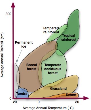
Biomes
Weathering & Sedimentary Rocks
Weathering Handout
Weathering Worksheet
Weathering Matching
Weathering Handout for students
Watersheds as Drainage Systems Required)
Flooding (Required)
Flood Forecasting
Flood Modelling
Virtual River
International Rivers
A river's journey from source to mouth
The River Severn from Source to Mouth
Dam Effects and Why we remove dams
China's Mega Dam Project Youtube
Teton Dam Disaster
Kame and Esker Formation
Glaciers and glacial landforms Group
Glacial Landforms PPT
Glacial Meltwater Landforms
Coasts and changing sea levels Group
Coastal Erosion and Deposition
Term 2 Schedule
Atmosphere Annenberg Video (Watch in class: Overview)a
Prehistoric atmosphere (Read different sections and prepare a graphic display for presentation)a
Atmospheric Circulation (Classwork: Overview and homework notes: Make sure you know this!)a
I.T.C.Z. Animation a
Climate of Tropical Regions
Atmospheric Circulation (Review)
Layers of the Atmosphere (Do this Assignment)
Atmosphere and Surface Energy Balance (Presentation in class and Classwork)a
Atmosphere Project (Individual or Group Assignment)a
Atmospheric Motion; (Background Reading)
Seasons Animation; (Sun-Earth Relations: In Class Demonstration)a
Planetary Circulation Patterns (Optional)
Solar Radiation & Seasons ( Optional Individual Lab)
Clouds
Clouds Presentation in Class (Presentation in class and discussion)
Air Pressure and Wind (Assignment) a
Land and Sea Breeze Animation a
Atmospheric Moisture (Optional Background Reading)
Atmospheric Moisture and Humidity Handout (Assignment)
Water Vapor Capacity of Air Handout (Assignment)
Atmospheric Stability Exercise (Handout)
Weather Systems (Optional Background Reading)
Atmospheric Interaction (Optional Background Reading)
El Nino (Current Events Reading)
El Nino Animation
Solar Energy (Solar Energy Application: Reading)
Climates (Optional Background Reading)
CO2 in a Year (Class demonstration and discussion)
Stable/ unstable air (Class demonstration)a
Stability PPTa
Weather Maps Practice and Help with your weather map activities
Climate Controls
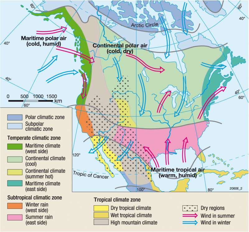
North America Airmasses
North America Climate
Climate and Agriculture
Climate and cropping systems
Kashmir Case Study
Mediterranean Climates
Snowball Earth
Evolution of a Hurricane
Hurricane Katrina: Damage
Ice Core Records (Class discussion)
Tropical Meterology
Bohren: Clouds (Required Reading) a
Videos
Why do Clouds Stay Up?
Thunderstorms Affect Air Pollution
Ice Core Samples
High and Low Pressure a
Fair skies and dark skies
Understanding Synoptic Charts
Atmospheric Circulation and Question Sheeta
Jetstreams a
Atmosphere and Solar Windsa
Ocean Currents
Climate Animations
Koeppen Climate Classification
Snowball Earth
Virtual Skies NASA
Isotherm Contour Drawing Exercise online
Isobar Drawing Exercise online
Jet Stream and Jet Stream Animation a
Jet Streams
Rising air animation
Water Vapor Calculator
Orographic Lift and Orographic Lift animation
Weather Animations
MeteoEarth
Predict the weather
Canada Weather Analysis Charts
PPT (Class Demonstrations of key ideas)
1. Air Pollutants
2. Air Pollutants
3. Mass, Weight, Density, Pressure
4. Rising and Sinking Air
5. Surface Weather Maps
6. Upper Level Charts
7. Surface Weather Maps
8. Surface Weather Maps Analysis
9. Energy, Energy Transport
10. Temperature, Conduction, Convection, Latent Heat
Soils
Mapping
Geocontext Profiler
Slope-gradient
Visualizing topography
Essential Reading: Weathering Group
Weathering
Weathering Flash Animation
Weathering
Essential Reading: Streams and Flooding Group
Weathering Diagrams and other geologic processes
Weathering Mechanical
Weathering Climate
Biomes
Weathering & Sedimentary Rocks
Weathering Handout
Weathering Worksheet
Weathering Matching
Weathering Handout for students
Watersheds as Drainage Systems Required)
Flooding (Required)
Flood Forecasting
Flood Modelling
Virtual River
International Rivers
A river's journey from source to mouth
The River Severn from Source to Mouth
Dam Effects and Why we remove dams
China's Mega Dam Project Youtube
Teton Dam Disaster
- Stream Processes
- Fluvial Processes
- Streams
- Stream Lab
- Entrenched Meanders
- Chasing Rivers, Part I, Colorado River
- Chasing Rivers, Part II, The Ganges
- Causes of Flooding
- Flood Plains
- Arid Regions
Kame and Esker Formation
Glaciers and glacial landforms Group
Glacial Landforms PPT
Glacial Meltwater Landforms
- Glacier Lab
- Glacier Works and this
- Glaciers and erosion
- Glacier Simulation
- Glacier Modelling
- Glaciers Norway
- History of Ice Ages
- Ice Ages
- Gulf Stream and the next ice age
- Glaciation Lower Mainland
- Really Cool Alpine Glaciation Website
- Lake Agassiz
- Glacier Glossary
Coasts and changing sea levels Group
Coastal Erosion and Deposition
Term 2 Schedule
Atmosphere Annenberg Video (Watch in class: Overview)a
Prehistoric atmosphere (Read different sections and prepare a graphic display for presentation)a
Atmospheric Circulation (Classwork: Overview and homework notes: Make sure you know this!)a
I.T.C.Z. Animation a
Climate of Tropical Regions
Atmospheric Circulation (Review)
Layers of the Atmosphere (Do this Assignment)
Atmosphere and Surface Energy Balance (Presentation in class and Classwork)a
Atmosphere Project (Individual or Group Assignment)a
Atmospheric Motion; (Background Reading)
Seasons Animation; (Sun-Earth Relations: In Class Demonstration)a
Planetary Circulation Patterns (Optional)
Solar Radiation & Seasons ( Optional Individual Lab)
Clouds
Clouds Presentation in Class (Presentation in class and discussion)
Air Pressure and Wind (Assignment) a
Land and Sea Breeze Animation a
Atmospheric Moisture (Optional Background Reading)
Atmospheric Moisture and Humidity Handout (Assignment)
Water Vapor Capacity of Air Handout (Assignment)
Atmospheric Stability Exercise (Handout)
Weather Systems (Optional Background Reading)
Atmospheric Interaction (Optional Background Reading)
El Nino (Current Events Reading)
El Nino Animation
Solar Energy (Solar Energy Application: Reading)
Climates (Optional Background Reading)
CO2 in a Year (Class demonstration and discussion)
Stable/ unstable air (Class demonstration)a
Stability PPTa
Weather Maps Practice and Help with your weather map activities
Climate Controls
North America Airmasses
North America Climate
Climate and Agriculture
Climate and cropping systems
Kashmir Case Study
Mediterranean Climates
Snowball Earth
Evolution of a Hurricane
Hurricane Katrina: Damage
Ice Core Records (Class discussion)
Tropical Meterology
Bohren: Clouds (Required Reading) a
Videos
Why do Clouds Stay Up?
Thunderstorms Affect Air Pollution
Ice Core Samples
High and Low Pressure a
Fair skies and dark skies
Understanding Synoptic Charts
Atmospheric Circulation and Question Sheeta
Jetstreams a
Atmosphere and Solar Windsa
Ocean Currents
Climate Animations
Koeppen Climate Classification
Snowball Earth
Virtual Skies NASA
Isotherm Contour Drawing Exercise online
Isobar Drawing Exercise online
Jet Stream and Jet Stream Animation a
Jet Streams
Rising air animation
Water Vapor Calculator
Orographic Lift and Orographic Lift animation
Weather Animations
MeteoEarth
Predict the weather
Canada Weather Analysis Charts
PPT (Class Demonstrations of key ideas)
1. Air Pollutants
2. Air Pollutants
3. Mass, Weight, Density, Pressure
4. Rising and Sinking Air
5. Surface Weather Maps
6. Upper Level Charts
7. Surface Weather Maps
8. Surface Weather Maps Analysis
9. Energy, Energy Transport
10. Temperature, Conduction, Convection, Latent Heat
Soils
Group Assignment:
The class breaks up into four groups: Weathering, Streams, Glaciers, Coasts. Each group will be responsible to prepare a series of landscape models, maps, pictures that are associated with both gradational and depositional processes and which examine how humans have dealt with each environment.
Weather and Climate will be based on class handouts. Also use the general reference section
Surface Weather Map Analysis
No comments:
Post a Comment